Talk to us

 Send Inquiry
Garmin
Garmin Specification
- Weight
- 122 g (4.3 oz)
- Features
- IPX7 Waterproof, Paperless Geocaching, Sun and Moon Information
- Interface Type
- USB
- Usage & Applications
- Hiking, Trekking, Adventure Sports, Field Survey
- Type
- Handheld Portable GPS
- Dimensions
- 2.4 x 6.1 x 1.3 (6.1 x 15.5 x 3.3 cm)
- GPS Accuracy
- < 10 meters (95% typical)
- Battery Backup
- Up to 18 hours
- Display
- 2.2 Monochrome, 128 x 160 pixels
- Frequency
- L1
About Garmin
Garmi
We offer a wide range of Garmin. Based on the latest technology, we offer GPS 60 Garmin for asset tracking systems also. These devices are based on advanced research & ensures good performance.
Advanced Navigation Made Simple
This Garmin portable GPS empowers you with accurate, efficient navigation, supporting over 2,000 waypoints and extensive track logging capabilities. Its paperless geocaching features and sun/moon information enhance outdoor adventures and surveying projects. The interface is user-friendly, letting you plot, save, and share routes conveniently.
Durability for Demanding Conditions
Engineered with an IPX7 waterproof rating, the device withstands harsh weather and challenging environments. With a compact 122g form factor and up to 18 hours of AA battery life, its reliable for lengthy excursions and fieldwork, ensuring your navigation system remains operational when you need it most.
Seamless Data Sharing & Global Coverage
Exchange routes and waypoints wirelessly between compatible devices for group expeditions or collaborative field surveys. The preloaded worldwide basemap enables global navigation, making this GPS unit highly versatile for exporters, importers, manufacturers, and traders across India and beyond.
FAQs of Garmin:
Q: How do I power the Garmin handheld GPS and what is its battery life?
A: This GPS unit operates on two AA batteries, which are not included in the package. It provides up to 18 hours of backup, making it suitable for day-long adventures and field surveys without frequent battery changes.Q: What types of maps and data can the device store and manage?
A: The Garmin GPS comes preloaded with a worldwide basemap and supports storing more than 2,000 waypoints and 200 routes. Additionally, it can log up to 10,000 track points and save 200 individual tracksideal for mapping large areas or long journeys.Q: When and where can I use this GPS unit effectively?
A: Designed for versatile outdoor use, this GPS unit is perfect for hiking, trekking, adventure sports, and field surveying. Its IPX7 waterproof rating ensures reliability in rainy, muddy, or humid environments, whether youre in Indias forests, mountains, or open terrains.Q: What is the process for wirelessly sharing data between Garmin devices?
A: To share routes, waypoints, and tracks wirelessly, both devices must be compatible and have the unit-to-unit transfer feature enabled. Simply activate wireless sharing from the device menu and connect to the nearby compatible unitno cable required.Q: How accurate is the GPS location, and what is its primary display type?
A: This handheld GPS offers precise navigation with less than 10-meter accuracy (95% typical) using the L1 frequency. It features a 2.2-inch monochrome display with a resolution of 128 x 160 pixels for clear, readable data output in various lighting conditions.Q: What are the benefits of the devices waterproof and rugged design?
A: The IPX7 waterproof rating protects the unit against immersion up to 1 meter for 30 minutes. Combined with its lightweight, sturdy build, the device is tough enough to endure outdoor mishaps, heavy rainfall, or accidental splashes, increasing its longevity in challenging environments.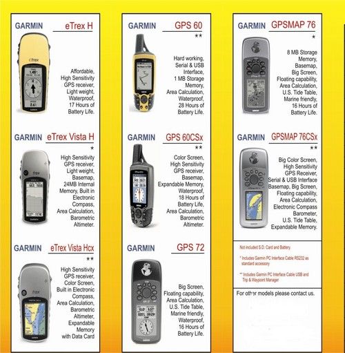
Tell us about your requirement

Price:
Quantity
Select Unit
- 50
- 100
- 200
- 250
- 500
- 1000+
Additional detail
Mobile number
Email

HINDUSTAN ARMY STORE
GST : 06ADEPB4243K1ZU
GST : 06ADEPB4243K1ZU

Mr. D J SINGH
(Director)
Mobile : +919416146360, +919671625109
SHOP NO 1, GITA ASHRAM MKT, LAL KURTI ROAD, Ambala Cantt - 133001, Haryana, India

Quick Link
Developed and Managed by Infocom Network Private Limited.
