Talk to us

 Send Inquiry
Garmin Gps 60 csx
Garmin Gps 60 csx Specification
- Features
- Map storage, waypoint and track logging, waterproof
- Weight
- 7.5 oz (213 g) with batteries
- Interface Type
- USB and Serial
- Type
- Handheld GPS Receiver
- Usage
- Hiking, Geocaching, Marine, Outdoor activities
- Dimensions
- 2.4 x 6.1 x 1.3 in (6.1 x 15.5 x 3.3 cm)
- Network
- Satellite GPS network (no cellular)
- GPS Accuracy
- <10 meters with WAAS
- Battery Backup
- Up to 18 hours with 2 AA batteries
- Display
- 2.6 inch, 256 x 160 pixel, TFT, 256 colors
- Frequency
- L1 (1575.42 MHz)
About Garmin Gps 60 csx
Garmin Gps 60 csx
Garmin unveiled the new GPSMAP 60CSx Hand held, targeted at outdoor and marine use, and featuring significant improvements over the existing 60CS model, at the 2006 Consumer Electronics Show.
The Garmin 60CSX comes in a rugged and (obviously) waterproof design. A barometric altimeter is included for highly accurate elevation data, while an integrated electronic compass displays the heading accurately. The most significant improvement has to be the enhanced GPS receiver, which can now acquire satellites faster so you can track your location even in heavy foliage or deep canyons.
The 60CSX supports microSD memory cards, and the unit comes with a 64MB card. The generous color TFT display is an added bonus.
FOR MORE ENQUIRY PLS MAIL US AT:
Waterproof and Durable for Outdoor Use
The Garmin GPS 60csx is crafted for tough environments, featuring an IPX7 water rating. This handheld device can be submerged up to one meter for 30 minutes, ensuring continuous operation in rain or when accidentally dropped in water. Its ideal for hiking, geocaching, boating, and other outdoor activities where rugged reliability is necessary.
Comprehensive Navigation Capabilities
With a preloaded basemap, support for 1,000 waypoints, and logging capacity for up to 10,000 track points, this GPS provides extensive mapping and track-recording potential. Its WAAS-enabled receiver offers high accuracy (<10 meters), while the 2.6-inch color TFT display delivers clear map visualization.
Long-Lasting Power and Flexible Connectivity
Designed for extended adventures, the unit operates for up to 18 hours on just two AA batteries. Data transfer is facilitated through both USB and serial interfaces for easy import and export of maps and tracks. The devices lightweight design makes it practical for prolonged carry during expeditions.
FAQs of Garmin Gps 60 csx:
Q: How waterproof is the Garmin GPS 60csx?
A: The Garmin GPS 60csx has an IPX7 rating, meaning it can be submerged in up to 1 meter of water for up to 30 minutes without damage. This makes it suitable for use in rain, wet environments, or boating activities.Q: What types of navigation data can the GPS 60csx store?
A: This device can store up to 1,000 user-defined waypoints, 50 reversible routes, 20 saved tracks, and can log tracks up to 10,000 points. It also comes with a preloaded basemap to facilitate on-the-go navigation.Q: When should I replace the batteries in my Garmin GPS 60csx?
A: For optimal performance, replace the two AA batteries when the device indicates low power or after approximately 18 hours of usage. Using high-quality batteries is recommended for longer operational life.Q: Where can I use the Garmin GPS 60csx?
A: The device is designed for versatile outdoor applications, including hiking, geocaching, marine navigation, and other outdoor pursuits. Its rugged build and waterproofing make it suitable for both terrestrial and aquatic environments.Q: What is the process for logging and exporting tracks on this device?
A: You can record tracks automatically as you move, storing up to 10,000 points. The device supports exporting and importing tracks and waypoints via USB or serial ports to compatible software for further analysis or sharing.Q: How can the Garmin GPS 60csx benefit outdoor enthusiasts?
A: With its robust construction, accurate GPS signal, and large waypoint capacity, the unit helps users navigate safely, record detailed routes, and revisit favorite locations with confidence during outdoor adventures.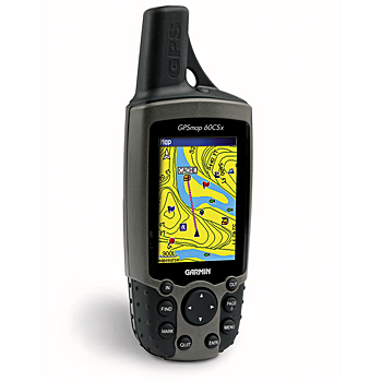
Tell us about your requirement

Price:
Quantity
Select Unit
- 50
- 100
- 200
- 250
- 500
- 1000+
Additional detail
Mobile number
Email

HINDUSTAN ARMY STORE
GST : 06ADEPB4243K1ZU
GST : 06ADEPB4243K1ZU

Mr. D J SINGH
(Director)
Mobile : +919416146360, +919671625109
SHOP NO 1, GITA ASHRAM MKT, LAL KURTI ROAD, Ambala Cantt - 133001, Haryana, India

Quick Link
Developed and Managed by Infocom Network Private Limited.
