Talk to us

 Send Inquiry
GARMIN GPS ETREX 10
MOQ : 1 Box
GARMIN GPS ETREX 10 Specification
- Memory Size
- Internal: 8 MB
- Usage & Applications
- Geocaching, hiking, fieldwork, navigation
- Features
- Rugged, waterproof (IPX7), paperless geocaching support, worldwide basemap
- Interface Type
- USB
- Type
- Handheld GPS device
- Usage
- Outdoor navigation, hiking, geocaching, adventure
- Function
- Handheld GPS navigation, waypoint marking, track and route recording
- Dimensions
- 5.4 x 10.3 x 3.3 cm
- Weight
- 141.7 g with batteries
- Network
- Satellite (GPS, GLONASS, WAAS)
- GPS Accuracy
- Less than 10 meters
- GPS Sensitivity
- High-sensitivity, WAAS-enabled GPS receiver with HotFix and GLONASS support
- Battery Backup
- Up to 25 hours (2x AA batteries)
- Display
- 2.2-inch monochrome display, 128 x 160 pixels
- Frequency
- 1,575.42 MHz L1
- Track Log
- 10,000 points, 100 saved tracks
- Waypoints
- 1000
- Sun & Moon Information
- Yes
- Case Material
- Rugged plastic
- Battery Type
- 2 x AA batteries (not included)
- Waterproof Standard
- IPX7
- Trip Computer
- Yes
- Routes
- 50
- Geocaching Friendly
- Yes, supports GPX files for geocaching
- Map
- Worldwide basemap (no advanced mapping support)
- Operating Temperature
- -20C to 70C (-4F to 158F)
About GARMIN GPS ETREX 10
Physical & Performance
| Physical dimensions | 2.1" x 4.0" x 1.3" (5.4 x 10.3 x 3.3 cm) |
| Display size, WxH | 1.4" x 1.7" (3.6 x 4.3 cm); 2.2" diag (5.6 cm) |
| Display resolution, WxH | 128 x 160 pixels |
| Display type | transflective, monochrome |
| Weight | 5 oz (141.7 g) with batteries |
| Battery | 2 AA batteries (not included); NiMH or Lithium recommended |
| Battery life | 25 hours |
| Water rating | IPX7 |
| High-sensitivity receiver | Yes |
| Interface | USB |
Maps & Memory
| Basemap | Yes |
| Custom POIs (ability to add additional points of interest) | Yes |
| Waypoints/favorites/locations | 1000 |
| Routes | 50 |
| Track log | 10,000 points, 100 saved tracks |
Outdoor Features
| Geocaching-friendly | Yes (Paperless) |
| Hunt/fish calendar | Yes |
| Sun and moon information | Yes |
| Area calculation | Yes |
PRICE @ 7999/- INC GST
Built for the Outdoors
With an IPX7 waterproof rating and a durable plastic case, the GARMIN GPS ETREX 10 is engineered to excel in rugged environments. Its operating temperature range of -20C to 70C makes it suitable for use in various climates, ensuring reliability whether youre hiking in the mountains or exploring wet forests.
Versatile Navigation Features
Mark up to 1,000 waypoints and 50 routes, and keep track of your journeys with the 10,000-point track log and 100 saved tracks. The device provides global coverage via a basic basemap and includes a trip computer, sun & moon data, and paperless geocaching support for a breadth of outdoor navigation needs.
Exceptional Battery Life
The ETREX 10 runs on two AA batteries (not included) and offers up to 25 hours of operation. This longevity allows for extended outings without frequent battery changes, so you can focus on your adventure with confidence.
FAQs of GARMIN GPS ETREX 10:
Q: How do I use the GARMIN GPS ETREX 10 for geocaching?
A: The ETREX 10 supports paperless geocaching by letting you import GPX files for detailed cache information, including hints and descriptions. Use the device to navigate to waypoints, log your finds, and track your location accurately during your geocaching adventures.Q: What is the process for marking and navigating to a waypoint on the ETREX 10?
A: To mark a waypoint, press the Mark button and save your current location. For navigation, select the desired waypoint from your saved list and the device will provide a route with direction and distance, helping you reach your target efficiently.Q: Where can the GARMIN GPS ETREX 10 be used effectively?
A: The device is suitable for outdoor pursuits such as hiking, geocaching, fieldwork, and adventure navigation. Its waterproof and rugged build makes it practical in wet, cold, or hot conditions, as well as remote areas where robust GPS navigation is crucial.Q: What benefit does the worldwide basemap offer on this device?
A: The worldwide basemap gives you an overview of global geography, roads, and landmarks, allowing basic orientation and route planning across different regions. While it does not support advanced mapping, its useful for fundamental navigation and situational awareness.Q: How long does the battery last and what type should I use?
A: The ETREX 10 operates for up to 25 hours using two AA batteries (alkaline or NiMH recommended). Batteries are not included; readily available AA cells make it easy to find replacements in most locations.Q: When is the best time to rely on the sun and moon information feature?
A: This feature proves valuable when planning outdoor excursions, such as timing hikes, hunting, or camping activities. Knowing sunrise, sunset, and moon phase helps optimize safety and experience while navigating in nature.Q: What is the GPS accuracy of the ETREX 10 and how does it achieve it?
A: The device delivers GPS accuracy within 10 meters, leveraging WAAS-enabled and GLONASS satellite systems with HotFix technology. This combination results in fast, precise positioning even in dense tree cover or rugged terrain.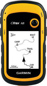
Tell us about your requirement

Price:
Quantity
Select Unit
- 50
- 100
- 200
- 250
- 500
- 1000+
Additional detail
Mobile number
Email

HINDUSTAN ARMY STORE
GST : 06ADEPB4243K1ZU
GST : 06ADEPB4243K1ZU

Mr. D J SINGH
(Director)
Mobile : +919416146360, +919671625109
SHOP NO 1, GITA ASHRAM MKT, LAL KURTI ROAD, Ambala Cantt - 133001, Haryana, India

Quick Link
Developed and Managed by Infocom Network Private Limited.
