Talk to us

 Send Inquiry
GARMIN GPS ETREX 20
GARMIN GPS ETREX 20 Specification
- Interface Type
- USB port
- Features
- Waterproof (IPX7), rugged construction, paperless geocaching, tracks and waypoints
- Memory Size
- 1.7 GB internal memory; microSD card slot
- Usage & Applications
- Outdoor exploration, mapping, geocaching, waypoint marking
- Type
- Portable GPS device
- Usage
- Outdoor use, hiking, trekking, geocaching
- Function
- Handheld GPS navigation
- Dimensions
- 5.4 x 10.3 x 3.3 cm
- Weight
- 141.7 g (with batteries)
- Network
- No cellular connectivity; supports GPS and GLONASS
- GPS Accuracy
- 3-5 meters (with WAAS/EGNOS/MSAS)
- GPS Sensitivity
- High-sensitivity, supported by WAAS-enabled GPS receiver
- Battery Backup
- Up to 25 hours with 2 AA batteries
- Display
- 2.2 color sunlight-readable display, 240 x 320 pixels
- Frequency
- Low power consumption, operates in GPS/GLONASS bands
- Languages Supported
- Multi-language
- Operating Temperature
- -20C to +70C
- Routes
- 200
- Waterproof Standard
- IPX7
- Battery Type
- 2 x AA (not included)
- Map Compatibility
- Supports Garmin Custom Maps and BirdsEye Satellite Imagery
- Track Log
- 10,000 points; 200 saved tracks
- Waypoints
- 2000
- Physical Buttons
- Yes
- USB Compatibility
- Compatible with PC
- Display Type
- Transflective, 65-K color TFT
About GARMIN GPS ETREX 20
| Physical & Performance | |
| Physical dimensions | 2.1" x 4.0" x 1.3" (5.4 x 10.3 x 3.3 cm) |
| Display size, WxH | 1.4" x 1.7" (3.5 x 4.4 cm); 2.2" diag (5.6 cm) |
| Display resolution, WxH | 176 x 220 pixels |
| Display type | transflective, 65-K color TFT |
| Weight | 5 oz (141.7 g) with batteries |
| Battery | 2 AA batteries (not included); NiMH or Lithium recommended |
| Battery life | 25 hours |
| Water rating | IPX7 |
| High-sensitivity receiver | |
| Interface | USB |
| Maps & Memory | |
| Basemap | |
| Ability to add maps | |
| Built-in memory | 1.7GB |
| Accepts data cards | microSD card (not included) |
| Custom POIs (ability to add additional points of interest) | |
| Waypoints/favorites/locations | 2000 |
| Routes | 200 |
| Track log | 10,000 points, 200 saved tracks |
| Outdoor Features | |
| Automatic routing (turn by turn routing on roads) | Yes (with optional mapping for detailed roads) |
| Geocaching-friendly | Yes (Paperless) |
| Sun and moon information | |
| Tide tables | Yes (with optional Bluechart) |
| Area calculation | |
| Picture viewer | |
Rugged Design for the Outdoors
Engineered for durability, the eTrex 20 boasts a rugged build with IPX7 waterproofing. It withstands harsh environments and temperatures from -20C to +70C, making it perfect for hiking, trekking, and geocaching adventures. Its lightweight and compact form factor (141.7 g; 5.4 x 10.3 x 3.3 cm) ensures easy portability.
High-Performance GPS Accuracy
With a high-sensitivity WAAS-enabled GPS receiver and support for GLONASS, the device offers precise accuracy of 3-5 meters even under challenging conditions. Its advanced track log feature (10,000 points; 200 saved tracks) allows reliable navigation and location tracking on every journey.
Versatile Mapping and Storage
The eTrex 20 is equipped with 1.7 GB internal memory and a microSD card slot. It supports Garmin Custom Maps and BirdsEye Satellite Imagery for enhanced map detail and versatility. USB compatibility allows convenient data transfer to your PC for exporting and importing routes, waypoints, and tracks.
FAQs of GARMIN GPS ETREX 20:
Q: How is the GARMIN eTrex 20 powered and what is the battery life?
A: The eTrex 20 runs on two standard AA batteries (not included), offering up to 25 hours of continuous operation. This long battery life ensures reliability during extended outdoor expeditions.Q: What mapping options and storage capacities does the device support?
A: The eTrex 20 comes with 1.7 GB internal memory and a microSD card slot. It supports Garmin Custom Maps and BirdsEye Satellite Imagery for enhanced map versatility and detail, ideal for diverse outdoor navigation.Q: What are the benefits of its high-sensitivity GPS and GLONASS support?
A: The combination of high-sensitivity GPS and GLONASS provides rapid satellite acquisition and maintains robust location accuracy (3-5 meters) even in dense forests or deep canyons, making navigation highly dependable.Q: How do you transfer waypoints, tracks, and maps to and from the device?
A: You can easily connect the eTrex 20 to your PC via its USB port. With Garmins software, users can export and import waypoints, routes, and maps for trip planning and data backup.Q: Where can the eTrex 20 be used, and what activities does it support?
A: Designed for outdoor usage, the eTrex 20 is ideal for hiking, trekking, geocaching, and other outdoor exploration. Its rugged design and waterproofing allow for dependable performance in various terrains and weather conditions.Q: What is the display type and what advantages does it offer?
A: The eTrex 20 features a 2.2-inch transflective, 65K color TFT display with a resolution of 240 x 320 pixels. This ensures excellent readability in direct sunlight and a clear view of maps and data.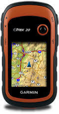
Tell us about your requirement

Price:
Quantity
Select Unit
- 50
- 100
- 200
- 250
- 500
- 1000+
Additional detail
Mobile number
Email

HINDUSTAN ARMY STORE
GST : 06ADEPB4243K1ZU
GST : 06ADEPB4243K1ZU

Mr. D J SINGH
(Director)
Mobile : +919416146360, +919671625109
SHOP NO 1, GITA ASHRAM MKT, LAL KURTI ROAD, Ambala Cantt - 133001, Haryana, India

Quick Link
Developed and Managed by Infocom Network Private Limited.
