Talk to us

 Send Inquiry
GARMIN GPS ETREX 30 X
MOQ : 1 Box
GARMIN GPS ETREX 30 X Specification
- Features
- Barometric altimeter, 3-axis electronic compass, IPX7 waterproof, paperless geocaching support
- Interface Type
- USB
- Usage & Applications
- Off-road navigation, location marking, adventure mapping
- Memory Size
- Built-in 3.7 GB, expandable via microSD
- Type
- Handheld GPS Device
- Usage
- Outdoor navigation, hiking, geocaching, trekking, adventure sports
- Function
- Handheld GPS navigation, mapping and tracking
- Dimensions
- 5.4 x 10.3 x 3.3 cm
- Weight
- 141.7 g (with batteries)
- Network
- GPS, GLONASS
- GPS Accuracy
- 3 - 5 meters
- GPS Sensitivity
- Highly sensitive, supports WAAS, GLONASS, and EGNOS
- Battery Backup
- Up to 25 hours
- Display
- 2.2-inch color TFT, 240 x 320 pixels, sunlight-readable
- Frequency
- Integrated GPS frequency band
- Area Calculation
- Yes
- Preloaded Maps
- Worldwide basemap
- Trip Computer
- Yes
- Custom Maps Compatible
- Yes
- Map Compatibility
- Supports BirdsEye Satellite Imagery (subscription required)
- Waypoints
- 2000
- Sun and Moon Information
- Yes
- Battery Type
- 2 AA batteries (not included)
- Photo Navigation
- Yes (navigate to geotagged photos)
- Hunt/Fish Calendar
- Yes
- Routes
- 200
- Track Log
- 10,000 points, 200 saved tracks
- Wireless Connectivity
- Yes (ANT+)
- Geocaching Friendly
- Yes (paperless)
- Water Rating
- IPX7
About GARMIN GPS ETREX 30 X
Physical & Performance | |
| Physical dimensions | 2.1" x 4.0" x 1.3" (5.4 x 10.3 x 3.3 cm) |
| Display size, WxH | 1.4" x 1.7" (3.5 x 4.4 cm); 2.2" diag (5.6 cm) |
| Display resolution, WxH | 240 x 320 pixels |
| Display type | 2.2" transflective, 65K color TFT |
| Weight | 5 oz (141.7 g) with batteries |
| Battery | 2 AA batteries (not included); NiMH or Lithium recommended |
| Battery life | 25 hours |
| IPX7 | |
| High-sensitivity receiver | Yes |
| Interface | USB |
| Barometric altimeter | Yes |
| Electronic compass | Yes |
| Unit-to-unit transfer (shares data wirelessly with similar units) | Yes |
Maps & Memory | |
| Basemap | Yes |
| Ability to add maps | Yes |
| Built-in memory | 3.7GB |
| Accepts data cards | microSD card (not included) |
| Custom POIs (ability to add additional points of interest) | Yes |
| Waypoints/favorites/locations | 2000 |
| Routes | 200 |
| Track log | 10,000 points, 200 saved tracks |
Outdoor Features | |
| Automatic routing (turn by turn routing on roads) | Yes (with optional mapping for detailed roads) |
| Geocaching-friendly | Yes (Paperless) |
| Yes | |
| Sun and moon information | Yes |
| Tide tables | Yes (with optional Bluechart) |
| Area calculation | Yes |
| Picture viewer | Yes |
Rugged, Reliable Handheld Navigation
The GARMIN GPS ETREX 30X combines durability with advanced navigation features to support enthusiasts in hiking, geocaching, and adventure sports. With IPX7 waterproofing and a robust construction, the device is built to withstand challenging outdoor conditions, ensuring reliable performance wherever your journey takes you.
Advanced Mapping and Tracking Capabilities
Preloaded with a worldwide basemap and supporting custom maps, the eTrex 30X enables users to track routes, mark waypoints, and navigate with impressive accuracy. Its high-sensitivity GPS receiver, barometric altimeter, and 3-axis electronic compass ensure you stay oriented even in difficult environments.
Feature-Rich for Outdoor Enthusiasts
The device boasts practical tools like area calculation, a hunt/fish calendar, sun and moon information, wireless ANT+ connectivity, and paperless geocaching. Its large memory, long battery life, and lightweight design make it a go-to companion for explorers who require both dependability and versatility.
FAQs of GARMIN GPS ETREX 30 X:
Q: How do I use the GARMIN GPS ETREX 30X for geocaching adventures?
A: The eTrex 30X supports paperless geocaching, allowing you to download and view geocache details directly on the device. Simply enable geocaching mode, load geocache files, and use the navigation features to find geotagged locations efficiently during your outdoor pursuits.Q: What is the battery life of the GARMIN GPS ETREX 30X, and what type of batteries does it require?
A: The device operates on two AA batteries (not included) and offers up to 25 hours of battery backup, making it suitable for extended trips without frequent battery changes. Use either alkaline or NiMH AA batteries for best performance.Q: When should I use the BirdsEye Satellite Imagery feature, and how do I access it?
A: BirdsEye Satellite Imagery provides detailed real-world map overlays for advanced navigation and planning. It is especially useful for off-trail adventures. Access requires a BirdsEye subscription and can be activated by downloading imagery to your microSD card via Garmin BaseCamp software.Q: Where can I utilize the eTrex 30Xs waterproof features?
A: With an IPX7 water rating, the eTrex 30X can be used in wet environments, such as during kayaking, rainy hikes, or adventures near water bodies. It can withstand submersion in water up to 1 meter deep for 30 minutes, ensuring reliable function in adverse weather.Q: What is the process for updating maps or adding custom maps to the device?
A: Maps can be updated and custom maps added by connecting the eTrex 30X to a computer via USB. Use Garmins software to transfer map files from your PC or download custom content. Additional storage is supported via microSD cards.Q: How accurate is the GPS positioning, and which satellite systems are supported?
A: The eTrex 30X offers positioning accuracy within 3-5 meters. It uses GPS, GLONASS, and EGNOS, delivering rapid and reliable acquisition even in dense forests or deep valleys.Q: What are the key benefits of the eTrex 30X for outdoor activities?
A: Its lightweight, rugged design, long battery life, advanced tracking, and mapping capabilitiesalong with features like area calculation, a hunt/fish calendar, and wireless connectivitymake the eTrex 30X an invaluable tool for hiking, trekking, geocaching, and adventurous exploration.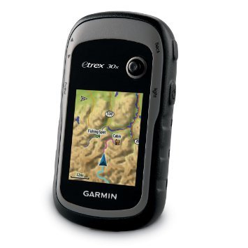
Tell us about your requirement

Price:
Quantity
Select Unit
- 50
- 100
- 200
- 250
- 500
- 1000+
Additional detail
Mobile number
Email

HINDUSTAN ARMY STORE
GST : 06ADEPB4243K1ZU
GST : 06ADEPB4243K1ZU

Mr. D J SINGH
(Director)
Mobile : +919416146360, +919671625109
SHOP NO 1, GITA ASHRAM MKT, LAL KURTI ROAD, Ambala Cantt - 133001, Haryana, India

Quick Link
Developed and Managed by Infocom Network Private Limited.
