Talk to us

 Send Inquiry
GARMIN GPS MAP 64 S
MOQ : 1 Box
GARMIN GPS MAP 64 S Specification
- Memory Size
- 4 GB internal memory, microSD card slot
- Features
- Barometric altimeter, 3-axis electronic compass, wireless data sharing
- Usage & Applications
- Hiking, geocaching, adventure, outdoor navigation
- Interface Type
- USB, NMEA 0183 compatible
- Type
- Handheld GPS Receiver
- Usage
- Outdoor navigation, trekking, surveying, adventure sports
- Function
- Handheld GPS mapping and navigation
- Dimensions
- 6.1 x 16.0 x 3.6 cm
- Weight
- 260 g with batteries
- Network
- GPS & GLONASS support
- GPS Accuracy
- 3-5 meters
- GPS Sensitivity
- High-sensitivity, quad helix antenna
- Battery Backup
- Up to 16 hours
- Display
- 2.6 sunlight-readable color display (160 x 240 pixels)
- Frequency
- 1.57542 GHz (L1)
- Waypoints/Favorites/Locations
- 2000
- Display Type
- TFT, sunlight-readable
- Paperless Geocaching
- Yes
- Custom Maps Compatible
- Yes
- Barometric Altimeter
- Yes
- Sun and Moon Information
- Yes
- Wireless Connectivity
- ANT+, Bluetooth
- Hunt/Fish Calendar
- Yes
- Basemap
- Yes, preloaded worldwide basemap
- Photo Navigation
- Yes (navigate to geotagged photos)
- Waterproof Rating
- IPX7
- Unit-to-unit Transfer
- Yes
- Track Log
- 10,000 points, 200 saved tracks
- Battery Type
- 2 x AA batteries (NiMH or Lithium recommended)
- Routes
- 200
- Electronic Compass
- 3-Axis with tilt compensation
- Area Calculation
- Yes
About GARMIN GPS MAP 64 S
| Physical & Performance: | |
| Physical dimensions | 2.4" x 6.3" x 1.4" (6.1 x 16.0 x 3.6 cm) |
| Display size, WxH | 1.43" x 2.15" (3.6 x 5.5 cm); 2.6" diag (6.6 cm) |
| Display resolution, WxH | 160 x 240 pixels |
| Display type | transflective, 65-K color TFT, transflective |
| Weight | 8.1 oz (230 g) with batteries |
| Battery | 2 AA batteries (not included); NiMH or Lithium recommended |
| Battery life | 16 hours |
| IPX7 | |
| Floats | No |
| High-sensitivity receiver | Yes |
| Interface | high-speed USB and NMEA 0183 compatible |
| Maps & Memory: | |
| Basemap | Yes |
| Preloaded maps | no |
| Ability to add maps | Yes |
| Built-in memory | 4GB |
| Accepts data cards | microSD card (not included) |
| Waypoints/favorites/locations | 5000 |
| Routes | 200 |
| Track log | 10,000 points, 200 saved tracks |
| Features & Benefits: | |
| Automatic routing (turn by turn routing on roads) | Yes (with optional mapping for detailed roads) |
| Electronic compass | Yes (tilt-compensated 3-axis) |
| Touchscreen | No |
| Barometric altimeter | Yes |
| Camera | no |
| Geocaching-friendly | Yes (Paperless) |
| Yes | |
| Hunt/fish calendar | Yes |
| Sun and moon information | Yes |
| Area calculation | Yes |
| Custom POIs (ability to add additional points of interest) | Yes |
| Unit-to-unit transfer (shares data wirelessly with similar units) | Yes |
| Picture viewer | Yes |
| Garmin Connect compatible (online community where you analyze, categorize and share data) | Yes |
Rugged Design and Durability
With an IPX7 waterproof rating and robust construction, the GARMIN GPS MAP 64 S can handle challenging outdoor conditions, including rain, mud, and accidental drops. Weighing just 260g including batteries, it balances durability with portability, making it suitable for a variety of field applications across outdoor navigation and adventure activities.
Advanced Navigation Features
This device is equipped with a highly sensitive quad-helix antenna, GPS/GLONASS dual network support, and a preloaded worldwide basemap for reliable tracking in demanding environments. Its 3-axis electronic compass and barometric altimeter deliver accurate heading and altitude data, even when stationary or in rugged terrain.
Practical for Multiple Applications
Whether you are hiking through forests, surveying land, geocaching, or engaged in adventure sports, the GPS MAP 64 S adapts to your needs. Wireless connectivity (ANT+ and Bluetooth), unit-to-unit data transfer, and support for custom maps make it easy to share information and customize navigation, ensuring every user finds it valuable for personal or professional purposes.
FAQs of GARMIN GPS MAP 64 S:
Q: How does the GARMIN GPS MAP 64 S perform in harsh weather conditions?
A: The device has an IPX7 waterproof rating, meaning it can withstand immersion in water up to 1 meter for 30 minutes. Its rugged design ensures reliable operation in rain, mud, and challenging terrain, making it suitable for outdoor navigation in diverse environments.Q: What type of batteries does the GPS MAP 64 S use and how long does it run?
A: The receiver operates on two AA batteries, with NiMH or Lithium types recommended for optimum performance. It provides up to 16 hours of battery life, making it feasible for long hikes, extensive surveys, or day-long adventures without frequent battery changes.Q: When should I use the 3-axis electronic compass and barometric altimeter features?
A: The 3-axis electronic compass is helpful when you need directional orientation, even while standing still or holding the device at an angle. The barometric altimeter is beneficial for accurate altitude readings and can help in monitoring changing weather conditions, crucial for climbers, trekkers, and outdoor explorers.Q: Where can I store maps and other navigation data on the device?
A: The GPS MAP 64 S comes with 4 GB of internal memory and a microSD card slot for expansion. You can store additional maps, waypoints, routes, and geotagged photos, enabling large-scale journeys and extended tracking capabilities.Q: What is the process for sharing data between units?
A: Using ANT+ wireless technology or Bluetooth, you can transfer waypoints, tracks, routes, and geocaches wirelessly to another compatible Garmin device. This is particularly useful for team navigation during expeditions or group adventures.Q: How does the GPS MAP 64 S benefit geocachers and outdoor adventurers?
A: Paperless geocaching support, customizable maps, photo navigation, and features like area calculation and hunt/fish calendars make it a comprehensive tool for geocachers, trekkers, and nature enthusiasts. Its high GPS accuracy (3-5 meters) and sunlight-readable display ensure dependable guidance in all light conditions.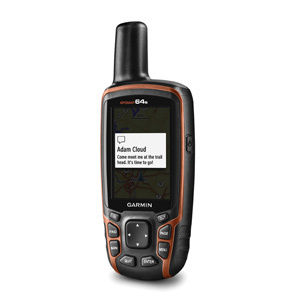
Tell us about your requirement

Price:
Quantity
Select Unit
- 50
- 100
- 200
- 250
- 500
- 1000+
Additional detail
Mobile number
Email

HINDUSTAN ARMY STORE
GST : 06ADEPB4243K1ZU
GST : 06ADEPB4243K1ZU

Mr. D J SINGH
(Director)
Mobile : +919416146360, +919671625109
SHOP NO 1, GITA ASHRAM MKT, LAL KURTI ROAD, Ambala Cantt - 133001, Haryana, India

Quick Link
Developed and Managed by Infocom Network Private Limited.
