Talk to us

 Send Inquiry
GARMIN GPS MONTERRA
GARMIN GPS MONTERRA Specification
- Interface Type
- microUSB, 3.5 mm audio jack, microSD card slot
- Memory Size
- 8 GB internal memory, expandable via microSD (up to 64 GB)
- Features
- Android OS, 8 MP camera with LED flash, GPS/GLONASS, 3-axis compass, barometric altimeter, waterproof (IPX7)
- Usage & Applications
- Topographic navigation, mapping, outdoor adventure, professional survey
- Type
- Handheld GPS receiver
- Usage
- Rugged outdoor navigation, hiking, geocaching, fieldwork
- Function
- Handheld GPS navigation and location tracking
- Dimensions
- 15.0 x 7.5 x 3.5 cm (5.9 x 2.95 x 1.4)
- Weight
- Approx. 331 g (11.7 oz) with batteries
- Network
- Wi-Fi, Bluetooth, ANT+, NFC
- GPS Accuracy
- < 10 meters (95% typical)
- GPS Sensitivity
- High-sensitivity receiver with quad helix antenna
- Battery Backup
- up to 22 hours with Lithium-ion battery or 16 hours with AA batteries
- Display
- 4-inch sunlight-readable multi-touch display (color, capacitive)
- Frequency
- 1.57542 GHz (L1), 1575.42 MHz
- Expansion Slot
- microSD up to 64 GB
- Waypoints
- 4,000
- Camera
- 8 MP autofocus with LED flash, 1080p video recording
- Water Rating
- IPX7 (waterproof)
- Battery Type
- Rechargeable NiMH/Li-ion or 3 AA batteries
- Audio Output
- 3.5 mm headphone jack and built-in speaker
- Wireless Capabilities
- Wi-Fi, Bluetooth, ANT+
- Preloaded Maps
- Worldwide basemap
- Product Code
- Monterra
- Operating System
- Android 4.0 (Ice Cream Sandwich)
- Display Resolution
- 272 x 480 pixels
- Temperature Range
- From -20C to 50C
- Track Log
- 10,000 points, 200 saved tracks
- Routes
- 200
- Sensors
- Accelerometer, Gyroscope, Barometric altimeter, 3-axis compass
- USB Interface
- High-speed USB
- Power Supply
- Rechargeable Li-ion battery pack or 3 AA batteries
About GARMIN GPS MONTERRA
| Physical & Performance: | |
| Physical dimensions | 2.9" x 5.9" x 1.4" (7.48 x 14.96 x 3.63 cm) |
| Display size, WxH | 2"W x 3.5"H (5.06 x 8.93 cm); 4" diag (10.2 cm) |
| Display resolution, WxH | 272 x 480 pixels |
| Display type | bright, transflective 65k color TFT, dual-orientation touchscreen; sunlight readable |
| Weight | 11.7 oz (331 g) with included lithium-ion battery pack; 13.2 oz (375 g) with 3 AA batteries (not included) |
| Battery | rechargeable lithium-ion (included) or 3 AA batteries (not included); NiMH or Lithium recommended |
| Battery life | up to 16 hours (lithium-ion); up to 22 hours (AA batteries) |
| Water rating | IPX7 |
| Floats | No |
| High-sensitivity receiver | Yes |
| Interface | High-speed USB |
| Maps & Memory: | |
| Basemap | Yes |
| Preloaded maps | yes (topographic), some models |
| Ability to add maps | Yes |
| Built-in memory | 6 GB (With Worldwide Basemap); 3 GB (With TOPO U.S. 100K Maps) |
| Accepts data cards | microSD card (not included) |
| Waypoints/favorites/locations | 4000 |
| Routes | 200 |
| Track log | 10,000 points, 200 saved tracks |
| Features & Benefits: | |
| Automatic routing (turn by turn routing on roads) | Yes (with optional mapping for detailed roads) |
| Electronic compass | Yes (tilt-compensated 3-axis) |
| Touchscreen | Yes |
| Barometric altimeter | Yes |
| Camera | yes (8 megapixel with autofocus and 1080p/30fps video; LED flash; automatic geo-tagging) |
| Geocaching-friendly | Yes (Paperless) |
| Custom maps compatible | Yes |
| Hunt/fish calendar | No |
| Sun and moon information | No |
| Area calculation | Yes |
| Custom POIs (ability to add additional points of interest) | Yes |
| Unit-to-unit transfer (shares data wirelessly with similar units) | Yes |
| Picture viewer | Yes |
| Garmin Connect compatible (online community where you analyze, categorize and share data) | Yes |
| Additional |
|
Advanced Outdoor Mapping Power
Garmin Monterra fuses advanced GPS/GLONASS precision with an Android interface, enabling extensive mapping and smart app integration. Its preloaded worldwide basemap, support for detailed topographic maps, and robust waypoint and route management equip users for any terrain. With high-sensitivity reception and quad helix antenna, Monterra maintains location accuracy even in dense forests or remote valleys, ensuring reliable navigation in challenging environments.
Designed for Durability and Versatility
Built to withstand harsh conditions, Monterra holds an IPX7 waterproof rating and operates in temperatures from -20C to 50C. The rugged housing, sunlight-readable display, and multiple battery options (rechargeable Li-ion or AA) support long, demanding outdoor adventures. Flexible connectivity via Wi-Fi, Bluetooth, and ANT+ expands field capabilities, while the 8 MP camera allows for geo-tagged photos and HD video documentation.
FAQs of GARMIN GPS MONTERRA:
Q: How does the GARMIN GPS Monterra perform in challenging outdoor conditions?
A: The Monterra is engineered for rugged use, featuring an IPX7 waterproof rating and reliable operation between -20C and 50C. Its sunlight-readable display and high-sensitivity receiver ensure functionality and accurate navigation even in harsh environments like forests, mountains, or during adverse weather.Q: What are the primary benefits of Monterras Android operating system?
A: With Android 4.0 (Ice Cream Sandwich), users can install mapping and utility apps for enhanced functionality. This flexibility augments traditional GPS tasks with options like field data collection, geocaching tools, and offline maps, enabling custom workflows and integration with cloud-based services via Wi-Fi.Q: When should I use the Monterras rechargeable battery pack versus AA batteries?
A: The rechargeable Li-ion pack is ideal for extended trips where recharging is possible, offering up to 22 hours of operation. AA batteries (NiMH or lithium) serve as convenient alternatives when recharging isnt feasible, providing up to 16 hours of backup. The option ensures flexibility across different expedition lengths.Q: Where can the Monterras camera and mapping features be most effectively utilized?
A: Monterras 8 MP camera with geo-tagging is optimized for field documentation, surveying, and adventure sports. Whether capturing waypoints during hikes, documenting environmental changes, or recording trips for mapping projects, its integration with GPS enhances both professional and recreational exploration.Q: What is the process for expanding Monterras storage for maps and media?
A: Monterra comes equipped with 8 GB internal memory, expandable via microSD cards up to 64 GB. Simply insert a compatible microSD into the slot to add custom map data, additional images, or field reports, ensuring extensive offline capacity for large mapping and multimedia files.Q: How accurate is the Monterras GPS positioning and how can I optimize it?
A: The Monterra delivers less than 10 meters GPS accuracy under typical conditions by using a high-sensitivity receiver and quad helix antenna. For best performance, use the device in open areas with a clear view of the sky and allow time for satellite acquisition when starting navigation.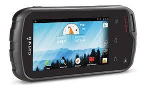
Tell us about your requirement

Price:
Quantity
Select Unit
- 50
- 100
- 200
- 250
- 500
- 1000+
Additional detail
Mobile number
Email

HINDUSTAN ARMY STORE
GST : 06ADEPB4243K1ZU
GST : 06ADEPB4243K1ZU

Mr. D J SINGH
(Director)
Mobile : +919416146360, +919671625109
SHOP NO 1, GITA ASHRAM MKT, LAL KURTI ROAD, Ambala Cantt - 133001, Haryana, India

Quick Link
Developed and Managed by Infocom Network Private Limited.
