Talk to us

 Send Inquiry
GARMIN MONTANA 650
MOQ : 1 Box
GARMIN MONTANA 650 Specification
- Features
- 3-axis compass, barometric altimeter, 5 MP autofocus camera, geotagging, waterproof IPX7, dual battery system
- Interface Type
- USB, NMEA 0183, microSD card slot
- Usage & Applications
- Outdoor navigation, geotagging, hiking, hunting, off-road adventures
- Memory Size
- 3 GB internal memory, plus microSD expandable
- Type
- Handheld GPS Navigator
- Usage
- Handheld outdoor mapping, hiking, adventure, marine and automotive
- Function
- Outdoor portable navigation, mapping, waypoint marking, geotagging photos
- Dimensions
- 7.5 x 14.2 x 3.6 cm (2.9 x 5.6 x 1.4)
- Weight
- 289 grams with battery
- Network
- Not applicable (standalone GPS, not cellular)
- GPS Accuracy
- < 10 meters (95%)
- GPS Sensitivity
- High-sensitivity GPS receiver with WAAS-enabled, HotFix and GLONASS support
- Battery Backup
- Up to 16 hours (Lithium-ion rechargeable or AA batteries)
- Display
- 4-inch sunlight-readable, dual orientation, TFT color touchscreen (272 x 480 pixels)
- Frequency
- 1.57542 GHz (L1 frequency GPS)
- Water Rating
- IPX7 (waterproof)
- Navigation Features
- Turn-by-turn driving directions (with compatible mapping), paperless geocaching
- Trip Computer
- Yes
- Preloaded Maps
- Worldwide basemap
- Area Calculation
- Yes
- Waypoints
- 2000
- Map Compatibility
- TOPO, BlueChart g2, City Navigator, Custom Maps
- Track Log
- 10,000 points, 200 saved tracks
- Unit-to-Unit Transfer
- Wireless sharing of waypoints, tracks, routes with compatible devices
- Camera
- 5 Megapixel digital camera with automatic geotagging
- Expansion Slot
- microSD card slot
- Picture Viewer
- Yes
- Barometric Altimeter
- Yes
- Compass
- 3-axis electronic compass
- USB Interface
- Yes
- Battery Type
- Rechargeable Lithium-ion pack or 3 AA batteries (NiMH, Lithium, or Alkaline)
- Routes
- 200
About GARMIN MONTANA 650
| Physical & Performance: | |
| Unit dimensions, WxHxD: | 2.9" x 5.7" x 1.4" (7.48 x 14.42 x 3.64 cm) |
| Display size, WxH: | 2"W x 3.5"H (5.06 x 8.93 cm); 4" diag (10.2 cm) |
| Display resolution, WxH: | 272 x 480 pixels |
| Display type: | bright, transflective 65k color TFT, dual-orientation touchscreen; sunlight readable |
| Weight: | 10.2 oz (289 g) with included lithium-ion battery pack; 11.7 oz (333 g) with 3 AA batteries (not included) |
| Battery: | rechargeable lithium-ion (included) or 3 AA batteries (not included); NiMH or Lithium recommended |
| Battery life: | up to 16 hours (lithium-ion); up to 22 hours (AA batteries) |
| Waterproof: | yes (IPX7) |
| Floats: | no |
| High-sensitivity receiver: | yes |
| Interface: | high-speed USB and NMEA 0183 compatible |
| Maps and Memory: | |
| Basemap: | yes |
| Preloaded maps: | no |
| Ability to add maps: | yes |
| Built-in memory: | 3.0 GB |
| Accepts data cards: | microSD card (not included) |
| Waypoints/favorites/locations: | 4000 |
| Routes: | 200 |
| Track log: | 10,000 points, 200 saved tracks |
| Features and Benefits: | |
| Automatic routing (turn by turn routing on roads): | yes (with optional mapping for detailed roads) |
| Electronic compass: | yes (tilt-compensated, 3-axis) |
| Touchscreen: | yes |
| Barometric altimeter: | yes |
| Camera: | yes (5 megapixel with autofocus; automatic geo-tagging) |
| Geocaching-friendly: | yes (paperless) |
| yes | |
| Photo navigation (navigate to geotagged photos): | yes |
| Hunt/fish calendar: | yes |
| Sun and moon information: | yes |
| Tide tables: | Yes (with optional Bluechart) |
| Area calculation: | yes |
| Custom POIs (ability to add additional points of interest): | yes |
| Unit-to-unit transfer (shares data wirelessly with similar units): | yes |
| Picture viewer: | yes |
| Garmin Connect compatible (online community where you analyze, categorize and share data): | yes |
Capture & Navigate with Precision
The Garmin Montana 650 merges advanced GPS navigation with a built-in 5 MP digital camera, allowing you to photograph and automatically geotag your outdoor explorations. Its high-sensitivity GPS engine, enhanced by WAAS and GLONASS, ensures accurate and reliable positioning even in rugged environments, making it perfect for outdoor mapping, hiking, and geocaching.
Versatile Power, Durable Design
Experience uninterrupted exploration with the dual battery systemchoose between a rechargeable lithium-ion pack or standard AA batteries for flexibility on long trips. The robust construction (IPX7) shields your device from water and dust, ensuring consistent performance whether youre in heavy rain, rivers, or dusty trails.
Expand Your Mapping Possibilities
Preloaded with a worldwide basemap and supporting numerous map formats such as TOPO, BlueChart g2, and City Navigator, the Montana 650 offers broad compatibility for land and marine navigation. The microSD card slot and wireless sharing allow you to expand memory, add custom maps, and effortlessly transfer data between compatible Garmin devices.
FAQs of GARMIN MONTANA 650:
Q: How does the Garmin Montana 650s geotagging feature work?
A: The built-in 5 MP camera captures photos and automatically tags them with GPS coordinates. This makes it easy to organize and locate your pictures on a map after your adventure.Q: What battery options does the Montana 650 support and how long does it last?
A: You can use either the included rechargeable lithium-ion battery or substitute three AA batteries (NiMH, lithium, or alkaline). Depending on settings and battery type, the device provides up to 16 hours of operation.Q: Where can the Garmin Montana 650 be used?
A: This device is engineered for a variety of environments, including hiking trails, off-road adventures, marine navigation, and automotive routes. Its waterproof (IPX7) and rugged design make it suitable for most outdoor and tough conditions.Q: What mapping capabilities does the Montana 650 offer out of the box?
A: It comes with a worldwide basemap preloaded and supports additional map types such as TOPO maps for hiking, BlueChart g2 for marine use, City Navigator for driving, and custom maps that can be added via microSD card.Q: How do I transfer waypoints and tracks to other Garmin devices?
A: Using the unit-to-unit wireless transfer feature, you can share waypoints, routes, and tracks with other compatible Garmin devices, making trip coordination and data exchange seamless.Q: What are the benefits of the 3-axis electronic compass and barometric altimeter?
A: The electronic compass provides accurate headings even when stationary or not held level, while the barometric altimeter gives you precise elevation and atmospheric pressure readings, enhancing navigation and weather awareness during your trips.Q: When is the built-in trip computer and area calculation feature helpful?
A: The trip computer tracks your traveled distance, time, speed, and other crucial data, which is valuable for planning and assessing your excursions. The area calculation tool is instrumental for measuring land and field size, useful in outdoor projects and resource management.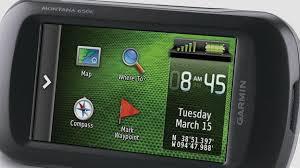
Tell us about your requirement

Price:
Quantity
Select Unit
- 50
- 100
- 200
- 250
- 500
- 1000+
Additional detail
Mobile number
Email

HINDUSTAN ARMY STORE
GST : 06ADEPB4243K1ZU
GST : 06ADEPB4243K1ZU

Mr. D J SINGH
(Director)
Mobile : +919416146360, +919671625109
SHOP NO 1, GITA ASHRAM MKT, LAL KURTI ROAD, Ambala Cantt - 133001, Haryana, India

Quick Link
Developed and Managed by Infocom Network Private Limited.
