Talk to us

 Send Inquiry
GARMIN MONTANA 680
MOQ : 1 Box
GARMIN MONTANA 680 Specification
- Memory Size
- 8 GB internal memory
- Usage & Applications
- Topographic navigation, waypoint marking, photo geotagging, route planning
- Interface Type
- USB, microSD card slot
- Features
- 3-axis compass, barometric altimeter, 8 MP autofocus camera, wireless sharing capability, waterproof
- Type
- Touchscreen Handheld GPS
- Usage
- Hiking, Adventure, Trekking, Geocaching
- Function
- Handheld Outdoor GPS Navigation
- Dimensions
- 7.48 x 14.42 x 3.64 cm
- Weight
- 289 g with batteries
- Network
- GPS/GLONASS satellite
- GPS Accuracy
- <10 meters (95% typical)
- GPS Sensitivity
- High-sensitivity GPS and GLONASS receiver
- Battery Backup
- Up to 16 hours with lithium-ion battery pack
- Display
- 4 inch sunlight-readable color touchscreen, 272 x 480 pixels
- Frequency
- N/A (Satellite based, not cellular)
- Touchscreen
- Glove-friendly, sunlight-readable capacitive touchscreen
- Camera
- 8-megapixel autofocus camera with automatic geotagging
- Water Rating
- IPX7 (waterproof up to 1 meter for 30 minutes)
- Sensors
- 3-axis electronic compass, barometric altimeter
- Operating Temperature
- -15C to 70C (5F to 158F)
- USB Interface
- High-speed USB and NMEA 0183 compatible
- Preloaded Maps
- Worldwide basemap; supports a variety of mapping options including TOPO, BlueChart, Birdseye Satellite Imagery
- Track Log
- Stores up to 10,000 points, 200 saved tracks
- Mounting Options
- Compatible with car, bike, marine, and handheld mounting accessories
- Waypoints
- Stores up to 4000 waypoints and 200 routes
- Battery Type
- Rechargeable lithium-ion pack (included) or 3 AA batteries (not included)
About GARMIN MONTANA 680
Physical & Performance | |
| Physical dimensions | 2.9" x 5.7" x 1.4" (7.48 x 14.42 x 3.64 cm) |
| Display size, WxH | 2"W x 3.5"H (5.06 x 8.93 cm); 4" diag (10.2 cm) |
| Display resolution, WxH | 272 x 480 pixels |
| Display type | bright, transflective 65k color TFT, dual-orientation touchscreen; sunlight readable |
| Touchscreen | Yes |
| Weight | 10.2 oz (289 g) with included lithium-ion battery pack; 11.7 oz (333 g) with 3 AA batteries (not included) |
| Battery | rechargeable lithium-ion (included) or 3 AA batteries (not included); NiMH or Lithium recommended |
| Battery life | up to 16 hours (lithium-ion); up to 22 hours (AA batteries) |
| Water rating | IPX7 |
| High-sensitivity receiver | Yes |
| Interface | high-speed USB and NMEA 0183 compatible |
| Camera | yes (8 megapixel with autofocus; automatic geo-tagging) |
| Barometric altimeter | Yes |
| Electronic compass | Yes (tilt-compensated 3-axis) |
| Unit-to-unit transfer (shares data wirelessly with similar units) | Yes |
Maps & Memory | |
| Basemap | Yes |
| Ability to add maps | Yes |
| Built-in memory | 4 GB |
| Accepts data cards | microSD card (not included) |
| Custom POIs (ability to add additional points of interest) | Yes |
| Waypoints/favorites/locations | 4000 |
| Routes | 200 |
| Track log | 10,000 points, 200 saved tracks |
Outdoor Features | |
| Automatic routing (turn by turn routing on roads) | Yes (with optional mapping for detailed roads) |
| Geocaching-friendly | Yes (Paperless) |
| Custom maps compatible | Yes |
| Hunt/fish calendar | Yes |
| Sun and moon information | Yes |
| Tide tables | Yes (with optional Bluechart) |
| Area calculation | Yes |
| Picture viewer | Yes |
Versatile Outdoor Navigation Tool
The Garmin Montana 680 is designed for adventure, supporting a range of activities from trekking and hiking to marine navigation and geocaching. Its glove-friendly, sunlight-readable touchscreen makes it effortless to operate in any weather or terrain, while ample internal memory and mapping support ensure youre always prepared.
Integrated High-Resolution Camera with Geotagging
Capture every moment with the 8-megapixel autofocus camera, which automatically geotags each photo, simplifying route documentation and waypoints marking. This feature is particularly valuable for geocachers, researchers, and outdoor photographers who need precise location data attached to their images.
Rugged and Reliable Construction
With an IPX7 waterproof rating and a durable build, the Montana 680 excels in harsh environments. The extended battery optionschoose between a rechargeable lithium-ion pack or standard AA batteriesand a battery backup of up to 16 hours provide peace of mind during extended adventures.
FAQs of GARMIN MONTANA 680:
Q: How does the Garmin Montana 680s camera enhance outdoor navigation?
A: The 8-megapixel autofocus camera in the Garmin Montana 680 automatically geotags each photo, allowing users to accurately document locations and revisit specific waypoints through visual reference. This is especially helpful for route planning, geocaching, and adventure journaling.Q: What mapping options are supported by the Montana 680?
A: The device comes preloaded with a worldwide basemap and supports a variety of mapping options such as TOPO for topographic detail, BlueChart for marine navigation, and Birdseye Satellite Imagery for real-view navigation. Maps can be expanded via microSD cards.Q: When should I use the different battery options for the Montana 680?
A: The handheld GPS operates on a rechargeable lithium-ion battery pack (included) or three AA batteries (not included). Use the lithium-ion pack for longer battery life and rechargeability, while AA batteries offer flexibility when traveling without charging facilities.Q: Where can the Montana 680 be mounted during outdoor activities?
A: The device is compatible with various mounting accessories, making it suitable for car dashboards, bicycles, marine vessels, or handheld use. This adaptability ensures reliable navigation whether you are hiking, biking, boating, or driving.Q: What is the process for marking and storing waypoints or tracks?
A: Simply use the touchscreen to record waypoints, routes, and tracks directly on the device. The Montana 680 can store up to 4,000 waypoints, 200 routes, and 10,000 track points, enabling thorough route planning and activity tracking for future reference.Q: How can I benefit from the Montana 680s high-sensitivity GPS and GLONASS receiver?
A: Its high-sensitivity GPS/GLONASS receiver provides accurate positioning even in challenging environments, such as dense forests or deep canyons. This ensures more reliable navigation, reducing the risk of getting lost during outdoor expeditions.Q: What are the main usage applications for the Garmin Montana 680?
A: Ideal for hiking, adventure trekking, marine navigation, geocaching, and field surveying, the Montana 680 offers comprehensive features including photo geotagging, waypoint marking, and wireless data sharing to support a wide range of outdoor and professional mapping activities.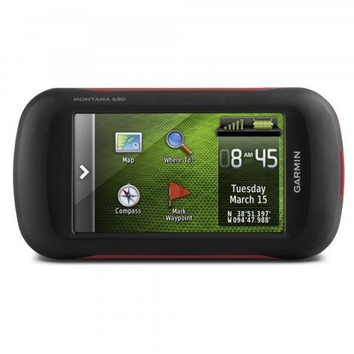
Tell us about your requirement

Price:
Quantity
Select Unit
- 50
- 100
- 200
- 250
- 500
- 1000+
Additional detail
Mobile number
Email

HINDUSTAN ARMY STORE
GST : 06ADEPB4243K1ZU
GST : 06ADEPB4243K1ZU

Mr. D J SINGH
(Director)
Mobile : +919416146360, +919671625109
SHOP NO 1, GITA ASHRAM MKT, LAL KURTI ROAD, Ambala Cantt - 133001, Haryana, India

Quick Link
Developed and Managed by Infocom Network Private Limited.
